Panaji | 23rd May 2025 —
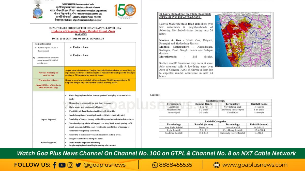
The India Meteorological Department (IMD) Goa has issued a red alert due to an ongoing heavy rainfall event across the state, warning of moderate to intense spells of rain with wind speeds of 50-60 kmph, gusting up to 70 kmph. The alert, issued at 10:30 AM IST, highlights that Panjim and all other talukas are very likely to experience severe weather in the next 3-4 hours, with the situation expected to persist over the next 24 hours.
🌊 Key Warnings & Forecast:
• Heavy to Very Heavy Rainfall across Panjim city and other talukas till 8:30 AM on 24th May 2025.
• Wind speeds ranging from 50-60 kmph, gusting up to 70 kmph, likely across the region.
• Radar data indicates widespread storm activity moving toward the Goan coastline.
⚠️ Impacts Expected:
• Waterlogging and inundation in low-lying areas and riverbanks.
• Disruption to road, rail, air, and ferry transport services.
• Potential flash floods, especially during high tides.
• Damage risk to weak structures, old buildings, and temporary shelters due to gusty winds.
• Possible landslides, rockfalls, or mudslides in hilly areas.
• Rough sea conditions along the Goa coast.
📍 Flash Flood Risk:
The IMD also flagged a low to moderate risk of flash floods in Goa, especially in areas with saturated soil or poor drainage. This includes parts of North Goa, as well as districts like Raigarh and Ratnagiri in Konkan, and Pune, Satara, Kolhapur in Maharashtra.
🚨 Action Suggested:
• Authorities may regulate traffic and suspend services in vulnerable zones.
• Residents in vulnerable or low-lying areas are advised to stay indoors and follow SDMA instructions.
• Precaution is urged for those living near riverbanks and hilly terrain.
Stay tuned to official IMD updates and local authorities for further instructions. Take all necessary precautions to ensure safety during this period of adverse weather.